
 Back to Landforms
Landforms are the result of a combination of constructive and destructive forces. Constructive forces include crustal deformation, volcanic eruption, and deposition of sediment, while destructive forces include weathering and erosion.
|
|
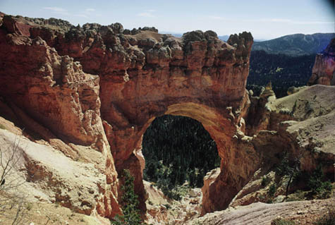
| Landform: Arch Arches are arch-shaped landforms produced by weathering and differential erosion. Example: Natural Bridge Arch Location: Bryce Canyon National Park Utah (Cyberbee Image) |
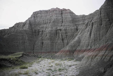
Landform: Badlands The Badlands were formed by the geologic forces of deposition and erosion. Deposition of sediments began 69 million years ago when an ancient sea stretched across what is now the Great Plains. After the sea retreated, successive land environments, including rivers and flood plains, continued to deposit sediments. Although the major period of deposition ended 28 million years ago, significant erosion of the Badlands did not begin until a mere half a million years ago. Erosion continues to carve the Badlands buttes today. Eventually, the Badlands will completely erode away. Location: South Dakota (Cyberbee Image) |
|
|
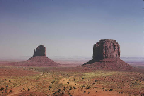
| Landform: Butte A butte is a flat-topped rock or hill formation with steep sides. The impressive sandstone formations: buttes, spires, and towers - the geological monuments that gave Monument Valley its name - are the result of centuries and millennia of erosion and uplift. Example: East Mitten and Merrick Butte Location: Monument Valley, Arizona (Cyberbee Image) |
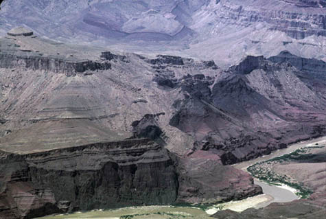
Landform: Canyon A canyon is a deep valley with very steep sides - often carved from the Earth by a river. Canyons are formed with wind and water erosion. Example: Grand Canyon Location: Grand Canyon National Park, Arizona (Cyberbee Image) |
|
|
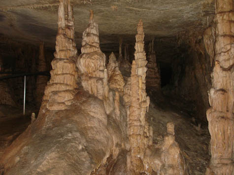
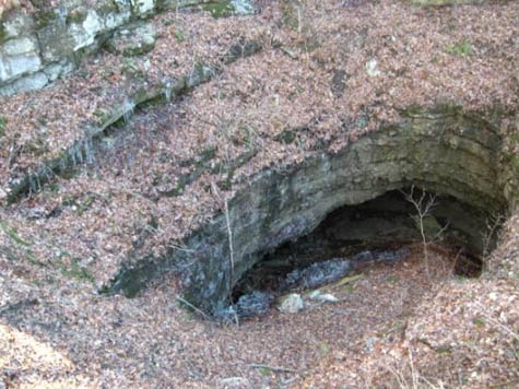
| Landform: Cave A cave is a large hole in the ground or in the side of a hill or mountain. Weathering and erosion work together to form caves. Nearly all caves are formed from a sedimentary rock called LIMESTONE. Water seeping through the ground dissolves the limestone. Underground rivers beat against the rock to form hollows. These hollows become bigger over time until a cavern or cave is formed. Example: Mammoth Cave Stalagmites |
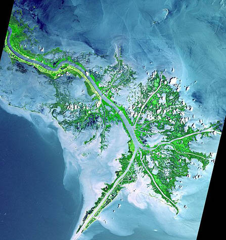
Landform: Delta A delta is a low, watery land formed at the mouth of a river. It is formed from the silt, sand and small rocks that flow downstream in the river and are deposited in the delta (deposition). A delta is often (but not always) shaped like a triangle (hence its name, delta, a Greek letter that is shaped like a triangle). Example: Mississippi River Delta Location: Louisiana (NASA Image) |
|
|
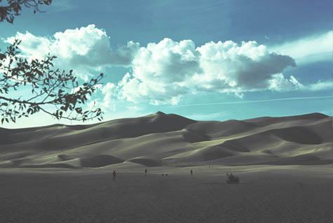
| Landform: Dune A dune is a hill or a ridge made of sand. Dunes are shaped by the wind and change all the time. Example: Great Sand Dunes National Park and Preserve The dunes were formed from sand and soil deposits of the Rio Grande and its tributaries, flowing through the San Luis Valley. Location: Colorado (Cyberbee Image) |
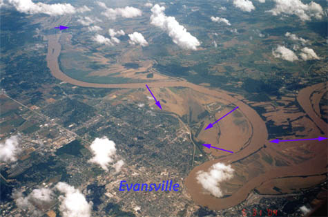
Landform: Floodplain A floodplain is an area of low-lying ground adjacent to a river, formed mainly of river sediments (deposition) and subject to flooding. Example: Ohio River On Memorial Day 2004, the Ohio River is seen flooding the area around Evansville, Indiana during a flight over Indiana. The blue arrows indicate areas where the muddy brown floodwater has flowed over its banks onto the floodplain. The muddy brown color when seen from an airplane is indicative of recent storm or flood activity. Location: Indiana (Image: C. Thomas.) |
|
|
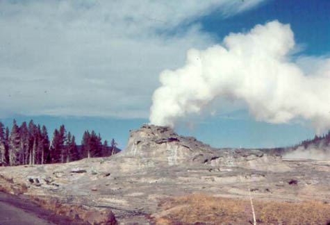
| Landform: Geyser A geyser is a natural hot spring that occasionally sprays water and steam above the ground. Yellowstone Wyoming Geysers are created by water that is heated beneath the Earth's surface. When water is both superheated by magma and flows through a narrow passageway underground, the environment becomes ideal for a geyser. The narrow passageway traps the heated water underground, where heat and pressure continue to build. Sooner or later, the pressure grows so great that the superheated water bursts out onto the surface. This explosion is called a geyser. Example: Castle Geyser Location: Yellowstone National Park, Wyoming (Cyberbee Image) |
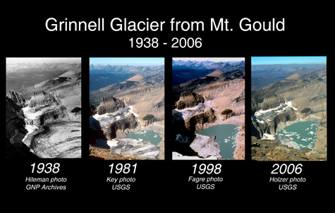
Landform: Glacier |

|
|
| Landform: Igneous Intrusion Example: Devils Tower The simplest explanation is that Devils Tower is a small intrusive body formed by magma which cooled underground and was later exposed by erosion. Location: Wyoming (Cyberbee Image) |
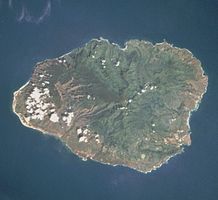
Landform: Island An island is a piece of land that is surrounded by water. Islands are formed in a variety of ways by volcanoes, when continental plates collide, and through deposits of sand that came from erosion. Example: Kauai Island Location: Kuai, Hawaii (Wikipedia Image) |
|
|
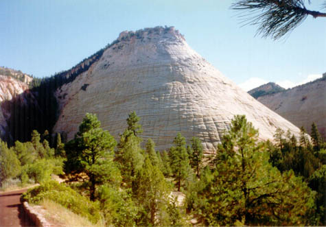
| Landform: Mesa Mesas are mountains with flat, level tops and steep, even sheer sides. Example: Checkerboard Mesa Millions of years of erosion have carved out grid like furrows in this Navajo sandstone mountain making it appear as a checkerboard. Location: Zion National Park, Utah (Cyberbee Image) |
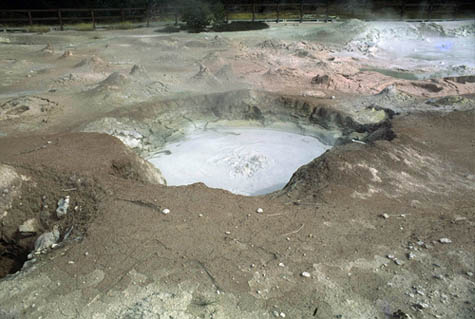
Landform: Mudpots Boiling ponds of mud (mudpots) are also present and are formed by sulfuric acid in the water. The acid dissolves the rock into tiny pieces of clay and the clay mixes with the hot water to make mud. As the steam rises from the within the earth, the mud bubbles as the steam releases into the air. This is chemical weathering. Location: Yellowstone National Park, Wyoming (Cyberbee Image) |
|
 |
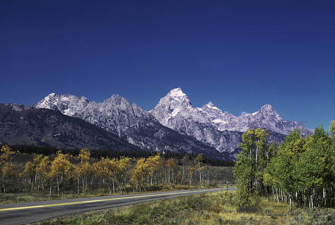
| Landform: Mountain A mountain is a very tall high, natural place on Earth - higher than a hill. The tallest mountain on Earth is Mt. Everest. Example: The Grand Tetons are part of the Rocky Mountains and formed over time by erosion. Location: Wyoming (Cyberbee Image) |
Landform: Plain Plains are flat lands that have only small changes in elevation. Plains are formed primarily by erosion and the deposition of sediment. Example: Great Plains Location: Kansas (Cyberbee Image) |
|
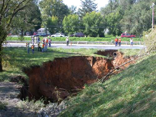 |
| Landform: Sinkhole A sinkhole is a place where the ground gives out and a hole opens up because the limestone has dissolved (eroded). The hole can be just a small shallow one, or it can be huge, swallowing homes and vehicles. Example: Near Mammoth Cave Location: Kentucky |
Landform: Sinkhole |
|
|
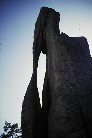
| Landform: Spire Granite Spires are Formed by years of rain, ice, and wind that weathered and eroded the granite rock. Example: Needle’s Eye This granite rock formation’s fluid lines make it look like it was sculpted by an artist. The “Needles Eye” is 30 to 40 feet high and the “eye” is 3 feet across. Location: Custer State Park in the Black Hills of South Dakota (Cyberbee Image) |
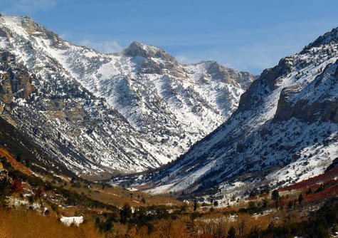
Landform: Valley A valley is a low place between mountains. Valleys formed by streams are V-shaped. Valleys formed by glaciers are U-shaped. Example: Lamoille Canyon U-shaped Valley Location: Nevada (Cyberbee Image) |
|
|
Landform: Valley |
Landform Volcano |

|
|
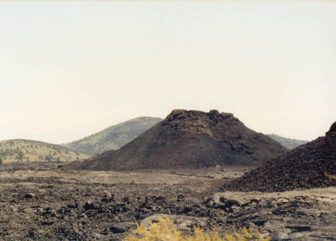
| Landform: Volcano A volcano is a mountainous vent in the Earth's crust. When a volcano erupts, it spews out lava, ashes, and hot gases from deep inside the Earth. Example: Mount St. Helens At 8:32 Sunday morning, May 18, 1980, Mount St. Helens erupted and blew down or scorched 230 square miles of forest. Location: Washington (USGS Images) |
|
Updated
April 10, 2015
© 1996 - 2015 Linda C. Joseph
All Rights Reserved
All CyberBee Graphics are Trademarked
Graphics by
Darlene Vanasco/Creative Director
Erika Taguchi/Designer & Illustrator
Hosting Provided by Iwaynet